Mangani's BigfootMaps

© 2004 DeLorme (www.delorme.com) Topo USA®

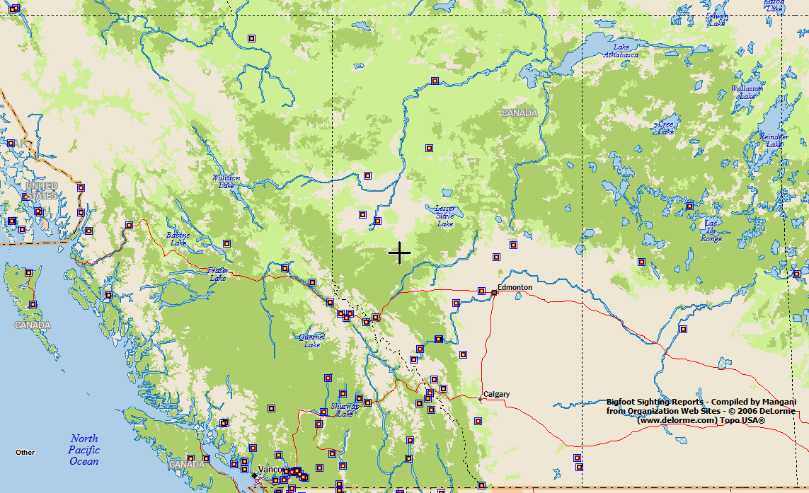
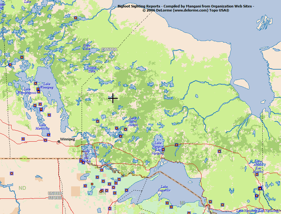
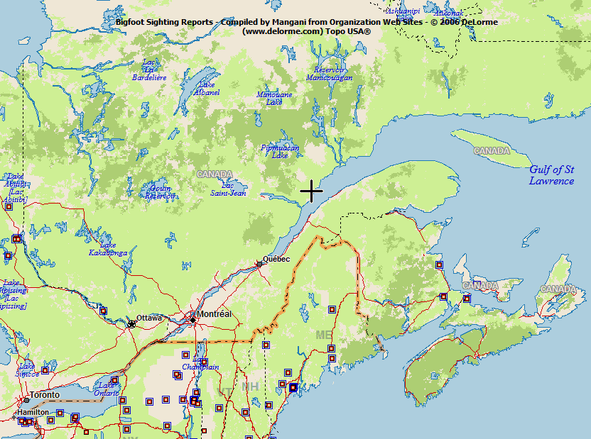
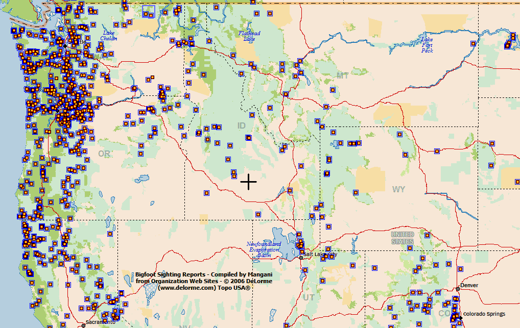
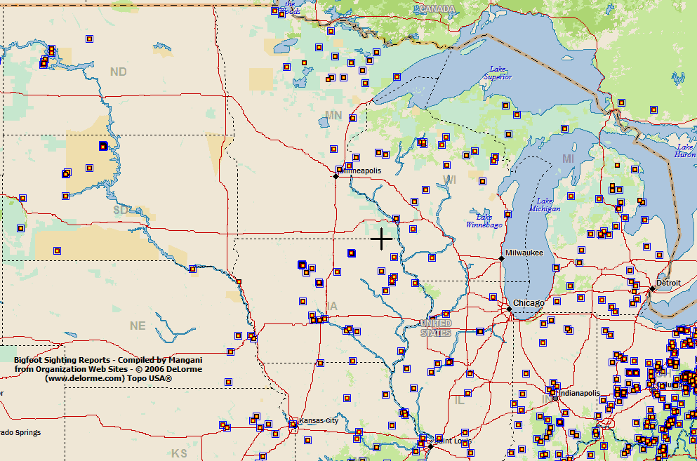
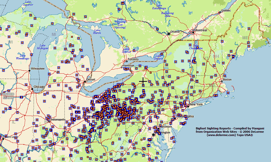
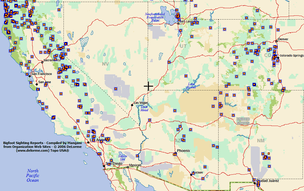
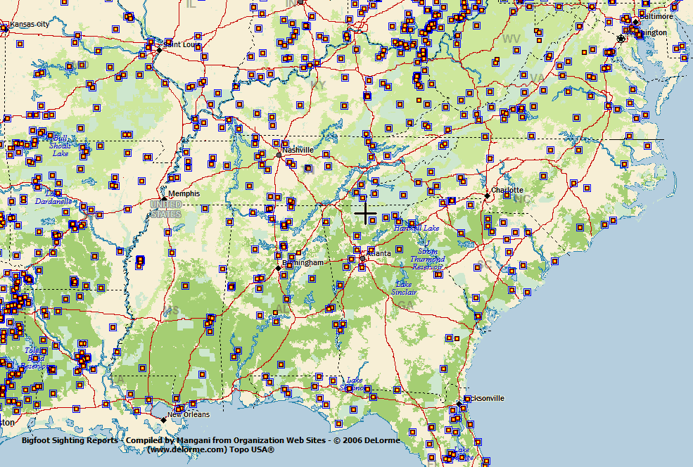
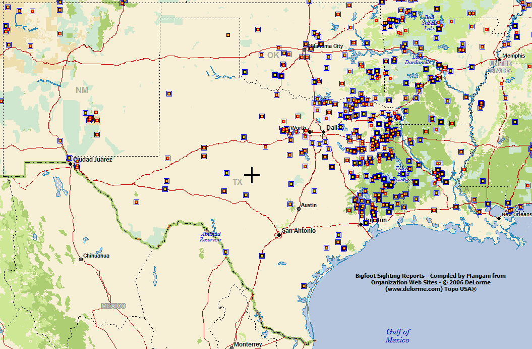
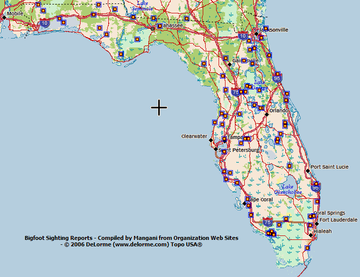
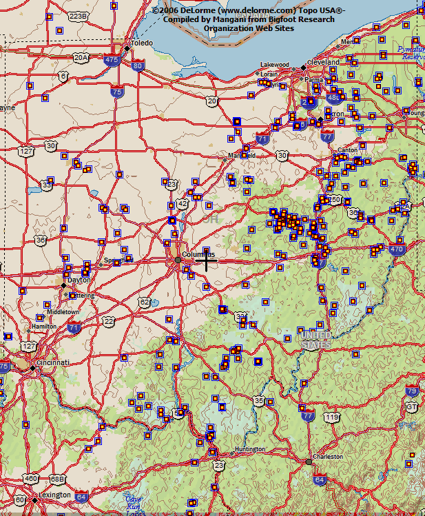
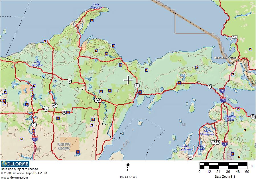
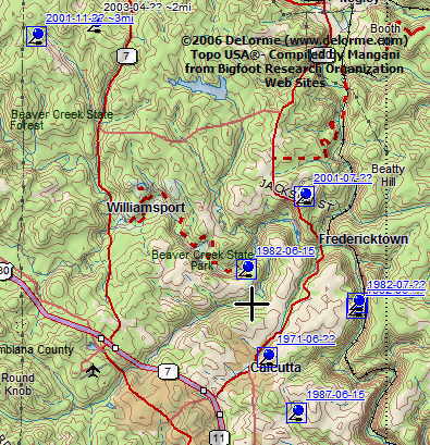
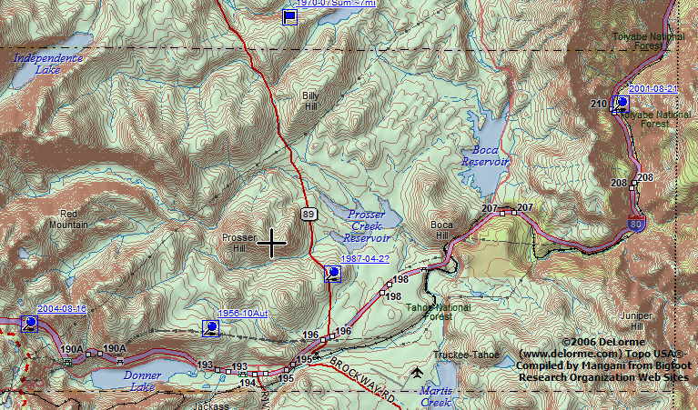
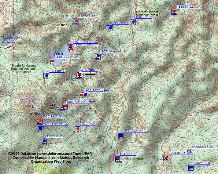
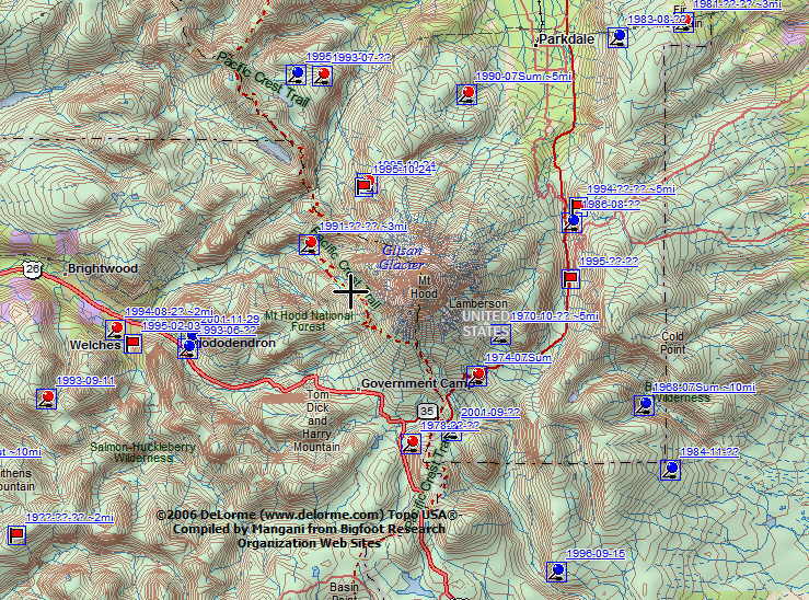
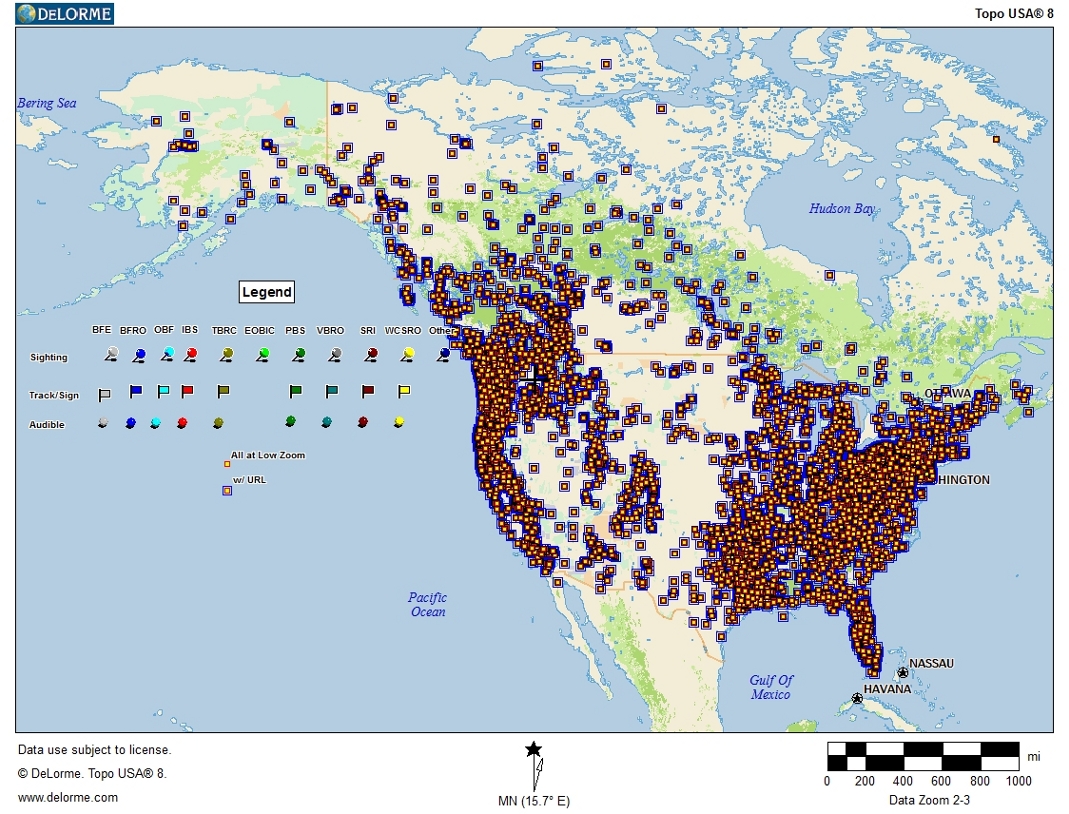
Overview Map of North American Bigfoot Reports
as reported by selected bigfoot research organization web sites
Maps Compiled Using DeLorme Topo USA® and 
Google Earth®


Google Earth® Overview Map 

GoogleEarth Version

To view in detail you may install Google Earth and download bigfootreports.kmz

Important: You must expand the timeline to see placemarks.

With GE 4.3 the timeline slider is invisible by default unless moused over (upper right center of screen). 
To make the timeline slider permanently visible you may select View - Show Time - Always.


You may also view the Google Earth map directly on this page using the Google Earth Plugin.


My Thoughts on Bigfoot

This project combines two of my interests – cryptozoology and mapping. This may partially explain why I have devoted so much time to it. But why, specifically, have I dedicated  this effort to mapping reports of a creature that remains unrecognized by mainstream science?

Initially I had planned to include only mapping information on this web page, as there are already many other web sites devoted to other aspects of the study of the bigfoot phenomenon. These sites make it  easy to find arguments, both pro and con, regarding the existence of these creatures - arguments that are more complete than the one I am about to make. All I am attempting here is to encourage anyone who happens upon this project  to not dismiss out of hand the possibility these creatures exist, but rather to keep an open mind and do some research of their own  before forming an opinion...

...thoughts continued here

Info, Comments, Questions:

Mangani Maps General Discussion

Mangani Maps Google Earth Discussion

Topo USA Software

DeLorme Forum

Google Earth Community


Mapped Bigfoot Report Web Sites:

Bigfoot Encounters

Bigfoot Field Research Orgnanization

Sasquatch Research Initiative

Texas Bigfoot Research Conservancy**

The International Bigfoot Society

Eastern Ohio Bigfoot Investigation Center

Ontario Sasquatch Research

OregonBigfoot

Pennsylvania Bigfoot Society

Virginia Bigfoot Researcb
Organization

Western Canadian Sasquatch Research Organization

Winnipeg River Sasquatch Association


Not Yet Mapped:

Gulf Coast Bigfoot Research Organization

Tirademan's Historical Archives


Bigfoot Discussion:

Bigfoot Forums


Other Bigfoot Maps:

BFRO's GoogleEarth Layers


Regional Sample Map Index

bfsightingUSAKtn.gif

bfsightingCanNWtn.gifbfsightingCanCEtn.gifbfsightingCanNEtn.gif

bfsightingUSNWtn.gifbfsightingUSNCtn.gifbfsightingUSNEtn.gif

bfsightingUSSWtn.gifbfsightingUSSCtn.gifbfsightingUSSEtn.gif

bfsightingUSSSCtn.gifbfsightingUSFLtn.gif

Click on map image to open larger sample map.


State Sample Map Index

OH/BFreportsOHtn.gifOhioPA/BFreportsPAtn.gifPennsylvania
WA/BFreportsWAtn.jpgWashingtonBFreportsMIupTN.jpgBFreportsMIlpTN.jpgMichigan

Detailed Sample Map Index

OH/columbianacountyOHTN.jpgColumbiana County, OHCA/BFROTruckeeTN.jpgTruckee, CAWA/BFreportsMtStHelensTN.jpgMt. St. Helens, WAOR/BFreportsMtHoodTN.jpgMt. Hood, OR


Please Note

The maps shown here are merely samples of the far greater possibilities available using this data with appropriate software. To take full advantage of this effort a copy of DeLorme Topo USA®, Google Earth®, or comparable mapping software is required. 

Downloading and importing the .dmt transfer file provided here will allow a DeLorme Topo USA user to prepare and view highly detailed maps displaying the locations of purported bigfoot activity in any US locale of interest. 

Google Earth® is a  popular free mapping application that utilizes satellite imagery to create and view maps. It does require a high speed internet connection to download the imagery. Google Earth® users should download and open the .kmz file. 

Both files include reports of tracks and audible encounters not shown on the regional sample maps displayed here.

Text files containing the sighting coordinate data (approximate) are also provided here for export to other mapping applications.

Users of this information should not assume that the locations shown are accurate. Locations are seldom precise enough to apply to a particular property.  The location coordinates are approximate and the margin of error will depend on the degree of precision included in the source report. Hyperlinks to the source reports are included. While some reports are located precisely, generally I believe that the typical margin of error is on the order of one mile. If the likely error is greater I have included an estimate. e.g., ~2mi, ~5mi, etc. Users of this information should respect all property rights.

Disclaimer: Mangani has no affiliation with DeLorme Mapping or Google, other than as a reasonably satisfied paying customer.

Anyone contemplating harm to these creatures should reconsider.
Intentionally injuring or killing even one of them could be a huge mistake.

Map Data Downloads:

Data is made available for use by all interested parties, with the provision that publication of this data in any manner must acknowledge the source.
Data last revised: 18 Jun 2009


Note: Generally these maps do not duplicate reports when they appear on more than one research organization web site. Generally such reports will be linked to the organizations according to the order they were mapped (see site log), though there may be some exceptions. Also, in a few cases, where unique details were noted at two different sources, duplicates have been mapped in order to provide links to these details.


DeLorme Topo USA®


Google Earth®

 
  bigfootreports.dmt

06/18/09

 bigfootreports.kmz

 06/18/09

Includes:
BigfootEncounters creature sightings 02/25/08  Included
BigfoootEncounters  tracksign reports 02/25/08  Included 
BigfootEncounters audible encounters 02/25/08  Included
  BFRO creature sightings

06/18/09

 Included  
  BFRO track sign reports

06/18/09 

 Included  
  BFRO audible encounters
06/18/09
 Included  
  EOBIC creature sightings

07/24/05

 Included  
IBS creature sightings* 02/23/06  Included
IBS track sign reports* 07/15/06  Included
IBS audible encounters* 07/15/06  Included
OBF creature sightings 01/13/08  Included
OBF track sign reports 12/07/07  Included
OBF audible encounters 02/11/08  Included
OSR creature sightings 09/09/08  Included
OSR track sign reports 02/27/08  Included
  PBS creature sightings

03/31/07

 Included  
  PBS track sign reports

"

 Included  
  PBS audible encounters

"

 Included  
  VBRO creature sightings

02/12/07

 Included  
  VBRO track sign reports

"

 Included  
  VBRO audible encounters

"

 Included  
  SRI creature sightings

05/31/08

 Included  
SRI track sign reports 05/31/08 Included
  TBRC creature sightings

02/26/09

 Included  
  TBRC track sign reports

02/08/09

 Included  
  TBRC audible encounters

02/26/09

 Included  
  Other creature sightings

09/05/08

 Included  
Other audible encounters 11/22/06  Included
WCRSO (note) audible encounters 08/04/07 Included
WCRSO (note) creature sightings 08/04/07 Included
WCRSO (note) track sign reports 08/04/07 Included
WRSA creature sightings 01/15/08 Included
WRSA track sign reports 01/15/08 Included


Site Log:
  • 17 Dec 2004 - Site created.
  • 19 Feb 2005 - City names and highways removed from sample maps; central region maps added; northwestern and northeastern regional maps extended.
  • 27 Feb 2005 - Began effort to include BFRO reports prior to 1990.
  • 12 Jun 2005 - Substantially completed mapping the pre-1990 BFRO reports.
  • 16 Jun 2005 - Completed hyperlinks to BFRO reports. (Hyperlink capability was not included in Topo USA when this project commenced, so a significant portion of post 1990 reports did not originally include hyperlinks to the source web site.)
  • 20 Jun 2005 - Over 99% of BFRO reports mapped. Reorganized reports by type (creature sighting, track/sign, audible). Recompiled regional sample maps for this web site to include only BFRO reports of creature sightings. While the map data files include reports of tracks and audible encounters and sighting reports from other organizations, these have been left out of the regional maps to minimize clutter at the scale displayed.
  • 21 Jun 2005 - Enhanced regional sample map selection to improve coverage.
  • 25 Jun 2005 - Added links to a sample detailed maps.
  • 04 Jul 2005 - Added all reports for Pennsylvania Bigfoot Society.
  • 08 Jul 2005 - Added all reports for Eastern Ohio Bigfoot Information Center.
  • 10 Jul 2005 - Added all reports for Texas Bigfoot Research Center**.
  • 24 Jul 2005 - Added all reports for Virginia Bigfoot Research Organization.
  • 12 Feb 2006 - Added all reports for Sasquatch Research Initiative.
  • 20 Feb 2006 - Added .kmz formatted file for viewing with Google Earth®.
  • 26 Mar 2006 - Google Earth version enhanced to improve display clarity.
  • 16 Jul 2006 - Completed addition of reports for the International Bigfoot Society. *Data currently include IBS reports with credibility rating of 1, 2, or 3 for all US and Canadian states and provinces. 
  • 17 Jul 2006 - Overview and sample maps updated with most recent data using DeLorme Topo USA 6. State sample maps added. 
  • 06 Nov 2006 - Added Michigan sample maps.
  • 18 Nov 2006 - Strengthened disclaimer on approximate nature of report locations.
  • 26 Jan 2007 - Added Google Earth overview image
  • 18 Mar 2007 - Added valid timestamp tags for use with Google Earth 4 Timeline capability.
  • 04 Aug 2007 - Added Western Canadian Sasquatch Research Organization reports.
  • 09 Dec 2007 - Added OregonBigfooot reports.
  • 15 Jan 2008 - Added Winnepeg River Sasquatch Association reports.
  • 26 Feb 2008 - Added Bobbie Short's Bigfoot Encounters reports.
  • 27 Feb 2008 - Added Ontario Sasquatch Research reports.
  • 14 May 2008 - **Revised links for older TBRC reports.  The TBRC totally redesigned their web site earlier this year which resulted in breaking the map links for all reports mapped from the original web site. So those URLs have now been revised to link to archived web pages stored by The Wayback Machine.
  • 01 Feb 2009 - Added Google Earth Plugin viewing capablity.
  • Subsequent efforts will likely include: adding reports from other research organizations; preparing analytical maps by time frame and report type.


Maps shown updated: 04 Aug 2007
Other site content updated: 18 Jun 2009

27238